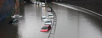
A new NASA study predicts record flooding in the 2030s due to a combination of rising sea levels and a “wobble” in the moon’s orbit around Earth.
The moon’s wobble: The Earth orbits the sun on what’s known as the ecliptic plane. As the moon orbits the Earth, its relationship with this plane changes — sometimes the moon is above it, and sometimes it’s below it.
Every 18.6 years, the moon completes one cycle of this above-below “wobble,” and during that time, its impact on the Earth’s tides changes.
For half of the cycle, the moon has a stronger effect on the tides — that results in higher high tides and lower low tides. For the other half of the cycle, tides are more moderate — low tide isn’t as low, and high tide isn’t as high.
Rising waters: We’ve known about this cycle since at least 1728, but a new study by NASA has put it in the spotlight.
“A business can’t keep operating with its parking lot under water.
Phil Thompson
According to those researchers, by the time the moon reaches the tide-amplifying part of its cycle in the mid-2030s, sea levels will have risen so much due to climate change that we could see record flooding along coastlines.
“Low-lying areas near sea level are increasingly at risk and suffering due to the increased flooding, and it will only get worse,” NASA Administrator Bill Nelson said in a news release.
Flood clusters: As part of their study, the researchers used sea rise scenarios, astronomical cycles, and flooding thresholds to predict when four cities in different parts of the U.S. are most at risk of high levels of flooding.
According to their model, most of the flooding events will occur in clusters, with some places experiencing up to a dozen floods a month for a few months straight.
“If it floods 10 or 15 times a month, a business can’t keep operating with its parking lot under water,” lead author Phil Thompson said. “People lose their jobs because they can’t get to work. Seeping cesspools become a public health issue.”
Get prepared: The good news is that we still have more than a decade until this is supposed to happen, and NASA plans to incorporate data from the new study into an online tool designed to help coastal areas prepare for flooding.
“Understanding that all your events are clustered in a particular month, or you might have more severe flooding in the second half of a year than the first — that’s useful information,” co-author Ben Hamlington said.
We’d love to hear from you! If you have a comment about this article or if you have a tip for a future Freethink story, please email us at [email protected].


